Construction Aerial Imaging

Out With the Old.
In With the New.

Aerial site imagery and 3D site models for construction teams. See progress, document conditions, and keep everyone on the same page.

Book a Demo

The DroneAir Advantage

Built for the demands of modern construction.

Clear Site Visibility

Get a current view of the full project area without relying on scattered ground photos or outdated imagery.

Days to Hours

A Part 107 Certified Pilot can capture an entire site in hours, with deliverables processed and shared quickly.

Progress Records

Build a dated visual history of site conditions and completed work at important project milestones.

BIM/CAD Integration

Export point clouds and aerial site imagery directly into Civil 3D, Procore, and AutoCAD. Seamless workflow integration.

Core Capabilities

Lifecycle data you can build on.

We turn drone flights into useful visual records your team can review, share, and use throughout the life of a project.

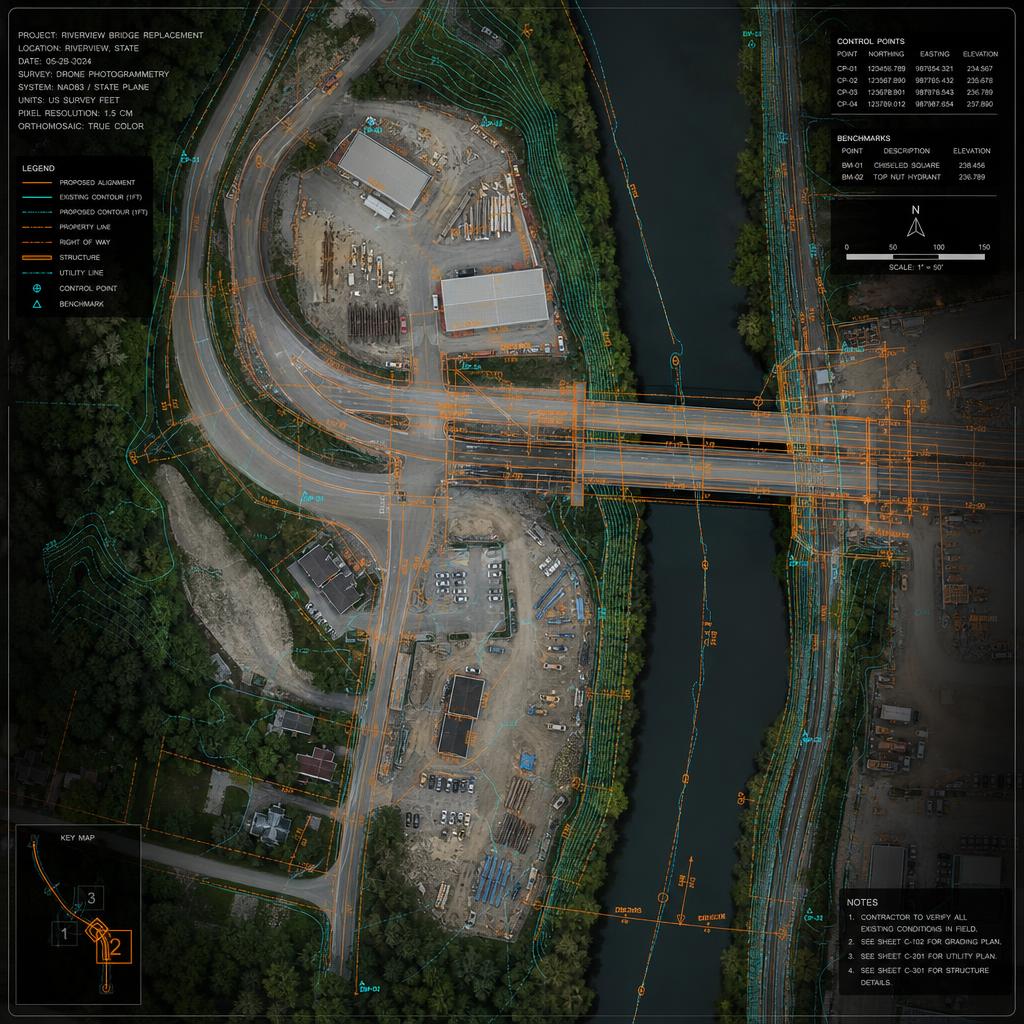
Aerial site imagery of a construction site

Pre-construction site documentation

Establish baseline site conditions with 3D outputs and high-res imagery before ground breaks.

Cut and fill reports

Obtain earthwork planning estimates derived from 3D surface models to support initial site preparation.

Tracking progress

Keep dated aerial progress records with repeat drone flights that show what changed on site.

Stockpile measurements

Use drone volume measurements to estimate stockpile quantities for planning.

Aerial photos overlaid on your design files

Compare aerial site imagery with your supplied design files in your preferred tools.

Project closeout

Document finished work with final-condition imagery and 3D outputs for handover records.

Visual data for recordkeeping

Keep a dated visual history of captured site conditions for team reference and project recordkeeping.

Qualification

All spatial and volumetric data supports visual planning and approximate estimates. We do not provide certified measurements or quantities.

Volumetrics

Aerial data for volumetric planning.

We collect overlapping drone imagery across your site and process it into 3D surface models. From those models we produce material quantity estimates, and compare them across repeat captures so your team can see how the site is changing.

  1. 01Overlapping imagery
  2. 023D surface model
  3. 03Quantity estimates
  4. 04Repeat comparisons
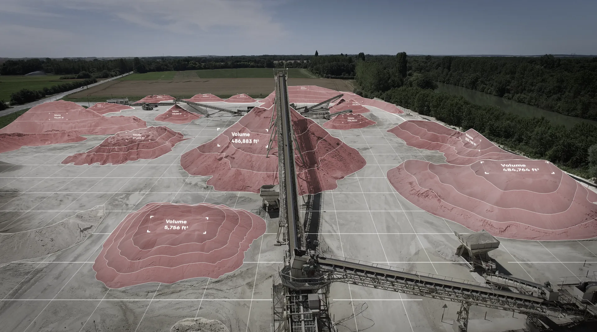
Illustrative aerial view of an aggregate yard with conveyor equipment, where stockpiles are shaded red with contour lines and labeled volume overlays over a grid on the ground.
Fig.Illustrative visualization of stockpile volume overlays. Not a verified Drone Air project or an actual client result.
01

Stockpile inventory

Estimate how much aggregate, soil, or fill sits on site from 3D surface models, without walking every pile.

02

Earthwork change tracking

Compare repeat captures of the same area to see where material has been moved, added, or removed between visits.

03

Material and logistics planning

Use quantity estimates to inform haul scheduling, delivery timing, and laydown space before decisions are made.

Qualification

Planning-grade estimates, not certified measurements. Use drone volume measurements for planning and material tracking, not engineering decisions.

Discuss your volumetric data needs

Deliverables Platform

Your site, digitized.

Review a temporary third-party demo, then talk to us about browser-ready deliverables for your own project. No account needed for this example.

Loading published example…

Field-Tested Equipment

Professional tools for professional results.

We use professional drone equipment built for dependable construction imaging. Every project is flown by a Part 107 Certified Pilot and backed by $5M in aviation liability insurance.

Consistent GPS-Referenced Flight Planning
Mechanical Global Shutter Cameras
High-Resolution Aerial Intelligence Cameras
Automated Terrain Awareness Flights
Redundant Flight Systems
Part 107 Certified Pilots
$5M Aviation Liability Insurance

Loading client perspectives…

Aerial Intelligence Pricing

Clear pricing for construction aerial intelligence.

Start with a base project minimum, then scale by the mapped site area. These planning estimates make early budgeting easier; every project receives a final written quote before flight.

Single capture

RTK 2D Aerial Intelligence

$1,000
minimum project
+ $20 / mapped acre

A current, high-resolution site map for planning, coordination, and progress documentation.

  • One coordinated RTK drone capture
  • Georeferenced 2D orthomosaic
  • Cloud-based map viewing and sharing
  • Standard processing and delivery
Request this package
Most complete

Combined deliverables

RTK 2D + 3D Aerial Intelligence

$1,750–$2,500
typical minimum
+ $35 / mapped acre

One coordinated flight plan processed into both 2D and 3D deliverables—without charging for two separate captures.

  • Everything in RTK 2D Aerial Intelligence
  • 3D point cloud and textured mesh
  • Browser-ready 3D site viewer
  • Combined capture and processing workflow
Request this package

Repeat program

Progress Aerial Intelligence

10–25% less
per repeat visit
after baseline setup

Consistent repeat flights for teams that need a dependable visual record throughout construction.

  • Initial baseline at the selected package rate
  • Matched capture area and deliverables
  • Organized project timeline for comparison
  • Repeat-visit savings based on cadence and scope
Request this package

Choose the right accuracy level.

Ground resolution describes image detail—such as inches per pixel. It is not the same as verified horizontal or vertical positional accuracy.

RTK alone is not an unconditional centimeter-accuracy promise.

01
RTK capture

RTK improves the positioning of captured images and supports consistent aerial intelligence. It does not, by itself, guarantee a specific horizontal or vertical accuracy.

02
Checkpoint-verified

Independent checkpoints are measured and compared with the finished map. Includes a documented horizontal and vertical accuracy report; typically adds $500–$1,500.

How quotes are calculated: acreage is based on the mapped site area, not parcel size. Travel, site access, operational complexity, restricted airspace, control placement, special deliverables, and rush turnaround may change the final quote. Prices shown are non-binding planning estimates.

Request a Quote

Ready to capture your site?

Tell us about your project, location, and mapped site area. Share the maps, 3D models, and repeat visits you need so we can confirm the project scope and quote.

Frequently Asked Questions

Drone photogrammetry turns overlapping aerial photos into detailed maps and 3D models, giving construction teams a clearer view of their site from planning through project completion.

Planning-grade estimates, not certified measurements. Aerial site imagery and 3D site models support visual planning and documentation; they are not boundary determinations and do not replace professional engineering or safety inspection.

DroneAir

Aerial site imagery, 3D site models, and dated aerial progress records for construction teams. Flown by Part 107 Certified Pilots and backed by $5M aviation liability insurance.

Services

  • Orthomosaic Aerial Intelligence
  • 3D Point Clouds
  • 3D Site Models
  • Stockpile Insights
  • Progress Documentation

Industries

  • Commercial Construction
  • Civil Engineering
  • Mining & Aggregates
  • Energy & Solar
  • Real Estate Development

Contact

© 2026 Drone Air LLC. All rights reserved.